Publications
 Partners


Partly cloudy conditions and cool to warm temperatures are expected for most of the country after days of rain and relentless storms swept through multiple regions, according to the South African Weather Service.
Impact-based warnings
A Yellow Level 2 warning for damaging wind and waves leading to disruption of beachfront and harbours/port activities has been issued between Kei Mouth and St Lucia.
DEVELOPING | Power outages continue across Western Cape, Eskom says
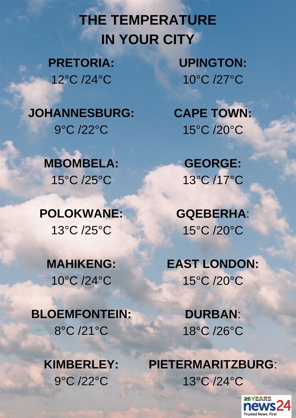
The weather in your region
Gauteng and the Free State will be partly cloudy and cool.
The expected UVB sunburn index is very high.
Fine and cool to warm temperatures are forecast in Mpumalanga and Limpopo.
The North West can expect partly cloudy and cool to warm conditions.
It will be partly cloudy and cool to warm, but fine and warm in the north of the Northern Cape.
The wind along the coast will be a moderate to fresh south to south-easterly.
The Western Cape will be partly cloudy in the north, otherwise cloudy and cool conditions are expected with isolated to scattered showers and rain.
The wind along the coast will be a fresh to strong south to south-westerly, becoming strong in the afternoon.
The expected UVB sunburn index is moderate.
??Weather and severe weather alerts for tomorrow, 10 April 2024.
— SA Weather Service (@SAWeatherServic) April 9, 2024
#SAWS
#weatheroutlook #southafricanweather #weatherupdate pic.twitter.com/tZUtlvWf0Y
Cloudy and cool to cold temperatures are forecast for the Eastern Cape with isolated showers and rain, but scattered along the coast.
The wind along the coast will be a fresh to strong south-westerly.
KwaZulu-Natal can expect partly cloudy and cool temperatures, but warm in the north-east.
It will become cloudy in the afternoon with isolated showers and rain in the east.
The wind along the coast will be a fresh to strong southerly to south-westerly, becoming near gale force from mid-morning.
The expected UVB sunburn index is moderate.