Publications
 Partners


Extreme high fire danger conditions are expected in North West and Free State, while severe thunderstorms resulting in localised flooding are expected in Mpumalanga, Limpopo and KwaZulu-Natal, according to the South African Weather Service.
Impact-based warnings
A yellow level 2 warning for severe thunderstorms resulting in localised flooding, large hail, damaging winds and difficult driving conditions is forecast over the Mpumalanga Highveld, the southern and central parts of Limpopo and the north-western parts of KwaZulu-Natal.
Fire warning dangers
Extremely high fire danger conditions are expected over the eastern parts of the North West and the northern parts of the Free State.
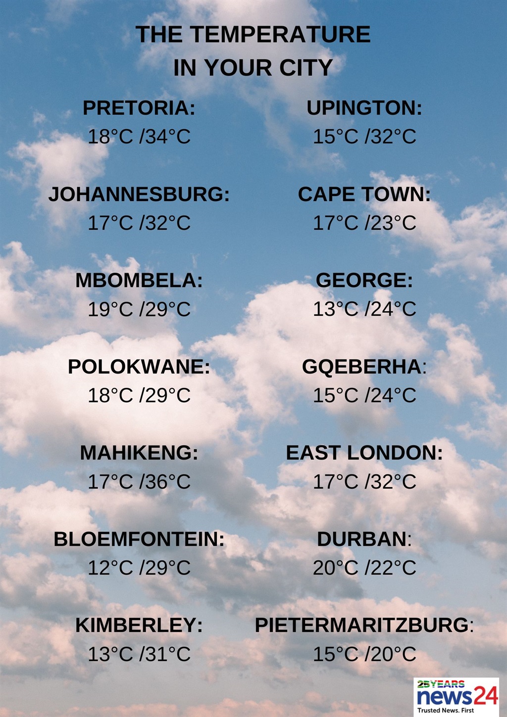
The weather in your region
Fine and hot, becoming partly cloudy with isolated afternoon thundershowers expected over Gauteng's central and northern parts.
The expected UVB sunburn index is very high.
It will be cloudy in the east of Mpumalanga, otherwise partly cloudy and warm to hot with scattered showers and thundershowers from the afternoon but isolated in the south-west.
In the east of Limpopo, it will also be cloudy, otherwise partly cloudy and warm to hot with isolated showers and thundershowers but scattered over the central and southern parts. It will be very hot in the Western Bushveld.
??Weather outlook for Thursday, 14-03-2024. Partly cloudy and warm to hot, with scattered to isolated showers and thundershowers in the east. #saws #weatheroutlook #southafricanweather pic.twitter.com/vbGZBdnV5r
— SA Weather Service (@SAWeatherServic) March 12, 2024
North West will be fine and hot to very hot, becoming partly cloudy over the central and eastern parts with isolated afternoon thundershowers in the extreme east.
Partly cloudy in the extreme east with isolated showers and thundershowers, otherwise fine and warm to hot in the Free State.
Fine and warm to hot but partly cloudy in the south of the Northern Cape at first.
The wind along the coast will be moderate to fresh south-easterly, becoming strong from the afternoon.
Partly cloudy over the eastern parts of the Western Cape at first, otherwise fine and warm to hot but cool along the coast.
The wind along the coast will be moderate to fresh southerly to south-easterly along the south-west coast, reaching strong in the afternoon, otherwise light and variable becoming moderate to fresh easterly to south-easterly from the afternoon.
The expected UVB sunburn index is extreme.
It will be partly cloudy and cool to warm, but cloudy with light isolated showers and rain in the north and east of the western half of the Eastern Cape. It will become fine over the interior in the afternoon.
The wind along the coast will be moderate to fresh south-westerly, becoming light to moderate easterly in the evening.
The eastern half of the province will be partly cloudy and warm with isolated thunderstorms in the north-west, otherwise cloudy and cool with scattered showers and thundershowers but widespread along the Wild Coast.
The wind along the coast will be moderate to fresh south-westerly, becoming light north-easterly in the evening.
Morning fog patches are expected in the south-west of KwaZulu-Natal, otherwise cloudy and cool to warm with scattered showers and thundershowers.
The wind along the coast will be fresh to strong southerly to south-westerly.
The expected UVB sunburn index is moderate.