Publications
 Partners


The South African Weather Service has forecast cloudy and warm conditions for most of the country, except for the Northern Cape and the north-eastern parts of the Western Cape, where a yellow level 2 warning has been issued for severe thunderstorms that may cause flooding.
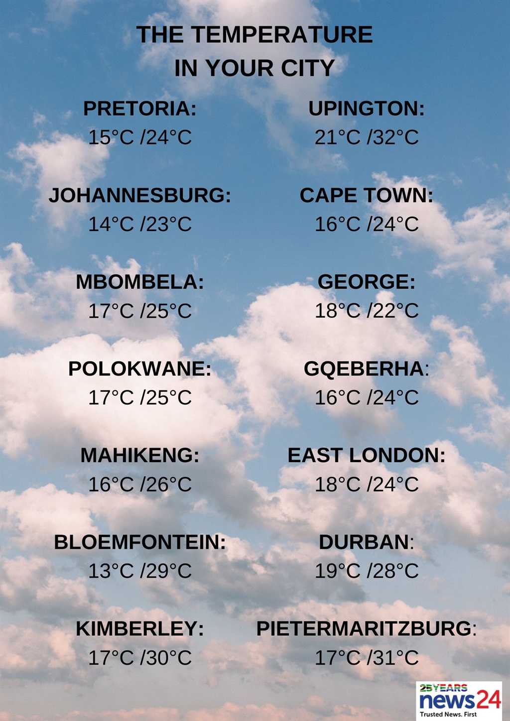
The weather in your region
Cloudy and cool but warm temperatures are expected in the north of Gauteng. It will become party-cloudy in the afternoon.
The expected UVB sunburn index is moderate.
Mpumalanga will have morning fog patches along the escarpment and southern Highveld. Otherwise, cloudy and cool, but warm conditions are forecast in the Lowveld.
Isolated morning showers are expected in the east.
Cloudy and cool to warm temperatures with isolated showers are also expected in Limpopo, except in the west and scattered over the north-eastern parts.
The North West will be cloudy in the east at first, otherwise, partly cloudy and warm to hot conditions with isolated showers and thundershowers are forecast in the west and south.
Cloudy skies with morning fog patches in the east are expected for the Free State. Otherwise, it will be partly cloudy and warm, with isolated showers and thundershowers, and scattered showers in the extreme south.
The Northern Cape can expect partly cloudy, windy and warm to hot conditions with isolated to scattered showers and thundershowers, except along the coast and adjacent interior, where it will be cool.
The wind along the coast will be a fresh to strong southerly to south-easterly.
Cloudy conditions are forecast for the Western Cape's south, otherwise, it will be partly cloudy and cool to warm, with isolated showers and thundershowers over the eastern parts but scattered in the extreme east.
Morning fog patches are expected over the central interior.
The wind along the coast will be a moderate to fresh south-easterly along the south-west and west coasts and will be strong by the evening.
Otherwise, a light southerly to south-westerly is expected, and will become moderate from the afternoon.
The expected UVB sunburn index is very high.
Weather update and severe weather alerts for tomorrow(26 March 2024): pic.twitter.com/nyT43C6Fr0
— SA Weather Service (@SAWeatherServic) March 25, 2024
The western half of the Eastern Cape can expect cloudy and cool conditions along the coast and adjacent interior, otherwise partly cloudy and warm temperatures with scattered showers and thundershowers.
The wind along the coast will be a light to moderate south-westerly.
Partly cloudy and warm conditions are forecast for the eastern half of the province with scattered showers and thundershowers, but isolated along the Wild Coast.
The wind along the coast will be light and variable, becoming south-westerly in the evening.
KwaZulu-Natal will be partly cloudy and warm but cool in places in the north with isolated showers and thundershowers except in the central interior but scattered in the extreme south-west.
The wind along the coast will be a moderate to fresh north-easterly but strong in the south.
The expected UVB sunburn index is very high.