Publications
 Partners


The South African Weather Service has issued multiple warnings for for severe thunderstorms, damaging winds and waves, and disruptive rainfall leading to flooding over several parts of the country.
Impact-based warnings
A Yellow Level 1 warning for severe thunderstorms is expected to result in damaging hail and strong winds in places over the eastern interior of the Eastern Cape. Damaging winds and waves are expected to result in difficulty in navigation, with small vessels at risk of taking on water, between Port Alfred and Port Edward from early morning.
A Yellow level 4 warning has been issued for disruptive rainfall leading to flooded roads and settlements, difficulty driving on dirt roads, damage to infrastructure and mud-based houses over the north-eastern parts of KwaZulu-Natal, as well as the Lowveld regions of Limpopo and Mpumalanga from Wednesday morning.
An Orange Level 6 warning was issued for disruptive rainfall leading to flooded roads and settlements, difficulty driving on dirt roads, damage to infrastructure and mud-based houses over Umkhanyakude District Municipality, uPhongolo, Nongoma, and uMfolozi local municipalities in KwaZulu-Natal, as well as the Nkomazi Local Municipality (southern Lowveld) in Mpumalanga from Wednesday morning.
Fire danger warnings
Extremely high fire danger conditions are expected in places over the Northern Cape, western parts of the Free State, as well as over the Khai-Ma and Hantam municipalities of the Northern Cape.
Weather for Tuesday, 12 March 2024.
— SA Weather Service (@SAWeatherServic) March 11, 2024
Partly cloudy and hot to warm with isolated showers and thunderstorms over the central and southern parts, as well as scattered to isolated showers and thundershowers over the extreme north eastern parts.
??warnings: Damaging winds & severe ?? pic.twitter.com/qq9zy58Kmt
Advisories
Heatwave conditions with persistently high temperatures are expected over the North West, Free State and Gauteng, eastern parts of the Northern Cape, central and eastern interior of the Eastern Cape, as well as the south-western Bushveld of Limpopo until Tuesday. These conditions will persist into Wednesday in Gauteng.
Extremely hot and uncomfortable conditions are expected in places over the Namakwa District of the Northern Cape, the West Coast District and the interior, and the Central Karoo of the Western Cape, as well as in parts of the Eastern Cape.
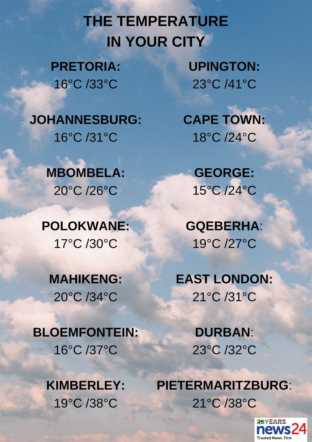
The weather in your region
Gauteng will be partly cloudy, but hot to very hot in the north.
The expected UVB sunburn index is extreme.
Cloudy and warm conditions are expected in the east of Mpumalanga, with morning fog patches on the Highveld. Otherwise, it will be partly cloudy and warm with isolated showers and thundershowers along the escarpment, but scattered in the Lowveld.
Limpopo can expect cloudy conditions in the east, with isolated to scattered showers and thundershowers. Otherwise, it will be partly cloudy and warm to hot.
Fine and hot to very hot temperatures are forecast in the North West and the Free State, becoming partly cloudy in the west and central parts with isolated showers and thundershowers.
The Northern Cape will be fine, with hot to very hot, to extremely hot temperatures in places over the northern parts.
It will become partly cloudy in the afternoon over the eastern parts where isolated showers and thundershowers are expected.
It will be windy over the interior by late afternoon.
The Western Cape will be cloudy and cool along the coast with fog in the morning. Otherwise, it will be partly cloudy with warm to hot temperatures.
The wind will be a light to moderate southerly to south-westerly along the West Coast, with a moderate to fresh westerly to south-westerly along the south coast, becoming light and variable from the evening.
The expected UVB sunburn index is extreme.
????Yellow level 1 warning for severe thunderstorms.
— SA Weather Service (@SAWeatherServic) March 11, 2024
Area: Eastern parts of Eastern Cape.
Valid: 12 March 2024 @ 12:00 SAST until 23:00 SAST. #saws #southafricanweather #weatheroutlook pic.twitter.com/QwLv0jX0m3
The western half of the Eastern Cape will have fog patches in places in the south at first. Otherwise, partly cloudy and hot to very hot temperatures are expected, with isolated afternoon thunderstorms in places. It will be warm along the coast.
It will become cloudy and windy in the south with isolated showers in places, mainly in the south-east.
The wind along the coast will be a fresh to strong westerly, becoming a strong south-westerly in the afternoon, moderating in the evening.
Fog patches are expected in the eastern half of the province in places south of the escarpment at first. Otherwise, it will be fine with hot to very hot, but extremely hot conditions in places.
It will become partly cloudy and windy with isolated showers and thundershowers in the afternoon, but scattered in the extreme north-east.
The wind along the coast will be a moderate to fresh north-easterly, becoming fresh to strong south-westerly from the south in the late morning.
KwaZulu-Natal can expect morning fog patches over the interior. Otherwise, partly cloudy and warm to hot temperatures are forecast with isolated showers and thundershowers in the extreme south-west and north-east.
The wind along the coast will be a fresh to strong easterly to north-easterly, becoming southerly to south-westerly from the evening.
The expected UVB sunburn index is very high.