Publications
 Partners


A Yellow Level 2 warning has been issued for severe thunderstorms with possible heavy downpours, hail, damaging winds and excessive lighting over the eastern parts of the North West, Free State, Gauteng, and the Highveld of Mpumalanga. This is according to the South African Weather Service.
These conditions may lead to the flooding of susceptible roads, low-lying areas and bridges, localised structural damage, disruption of services due to power surges, as well as danger to life.
Fire danger warnings
Extremely high fire danger conditions are expected in the Kamiesberg municipality, as well as the central parts of the Northern Cape.
Weather outlook for the next 3 days pic.twitter.com/26nX79ovIY
— SA Weather Service (@SAWeatherServic) March 19, 2024
Advisories
A heatwave with persistently high temperatures is expected in places over the North West, Free State, and central and eastern parts of the Northern Cape until Wednesday, and over the north-eastern interior of the Eastern Cape until Friday.
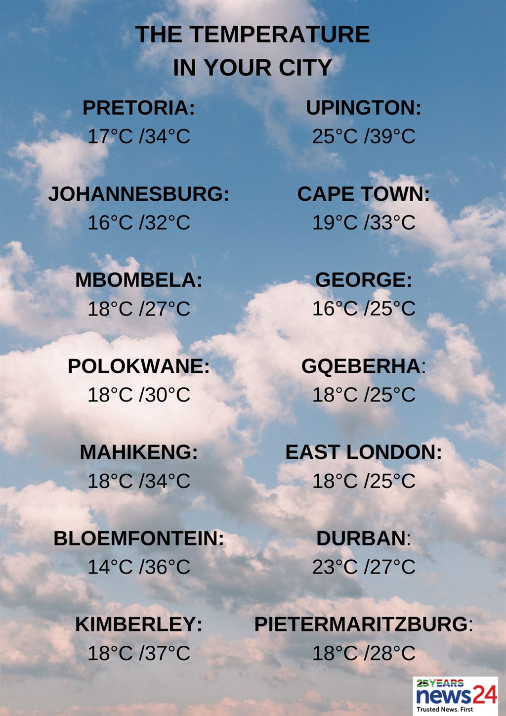
The weather in your region
Fine conditions are forecast in Gauteng, becoming partly cloudy and warm to hot with scattered afternoon thundershowers.
The expected UVB sunburn index is very high.
Mpumalanga will be cloudy in the east with morning fog patches along the escarpment. Otherwise, partly cloudy and cool to warm temperatures with isolated showers and thundershowers are expected, but scattered over the Highveld.
Cloudy conditions are expected in the east for Limpopo. Otherwise, partly cloudy and warm to hot temperatures with isolated showers and thundershowers are forecast, but scattered over the south-central parts, excluding the Limpopo Valley.
The North West will be partly cloudy with hot to very hot conditions and isolated showers and thundershowers, but scattered in the east.
Partly cloudy and warm to hot temperatures are forecast in the Free State, with isolated showers and thundershowers, but scattered in the east.
The Northern Cape can expect cloudy conditions with fog along the coast in the morning. Otherwise, fine and warm to hot but very to extremely hot temperatures are forecast in the central and eastern parts.
Isolated showers and thundershowers are expected, except in the south and extreme west.
The wind along the coast will be light and variable in the morning, otherwise moderate to fresh southerly to south-easterly.
Morning and evening fog are expected in the southern areas of the Western Cape, with partly cloudy conditions over the southern and eastern parts. Otherwise, fine and warm to hot, but very hot in parts of the West Coast.
The wind along the coast will be light to moderate southerly north of Table Bay. Otherwise, a fresh to strong south-easterly is expected.
The expected UVB sunburn index is very high.
The western half of the Eastern Cape can expect cloudy and cool conditions with light rain and drizzle in the south-east. Otherwise, partly cloudy and warm, but hot in parts of the extreme north.
The wind along the coast will be a light to moderate easterly, but fresh to strong in the afternoon.
Cloudy and warm to cool conditions are expected in the eastern half of the province, with isolated showers and rain along the coast and adjacent interior. Otherwise, partly cloudy and warm to hot temperatures are expected with isolated thunderstorms in the Drakensberg during the afternoon.
The wind along the coast will be light and variable at first, otherwise moderate to fresh north-easterly.
KwaZulu-Natal will be partly cloudy with morning fog in places over the northern escarpment, becoming cloudy and cool to warm with scattered showers and thundershowers.
The wind along the coast will be a light south-westerly in the extreme south in the morning, otherwise a moderate to fresh north-easterly, but south-easterly in the north from the afternoon.
The expected UVB sunburn index is very high.