Publications
 Partners


Widespread rain is expected in a number of provinces across the country, along with warm to cool temperatures throughout, according to the South African Weather Service.
Impact-based warnings
A Yellow Level 2 warning has been issued for severe thunderstorms with heavy downpours and strong damaging winds that will result in flooding of susceptible roads, low-lying areas and bridges over the southern parts of the Namakwa in the Northern Cape, central Karoo in the Western Cape, and western parts of KwaZulu-Natal.
A Yellow Level 1 warning has also been issued for disruptive rain leading to flooding of susceptible settlements and roads, as well as low-lying areas and bridges in places over the north-eastern parts of the Eastern Cape.
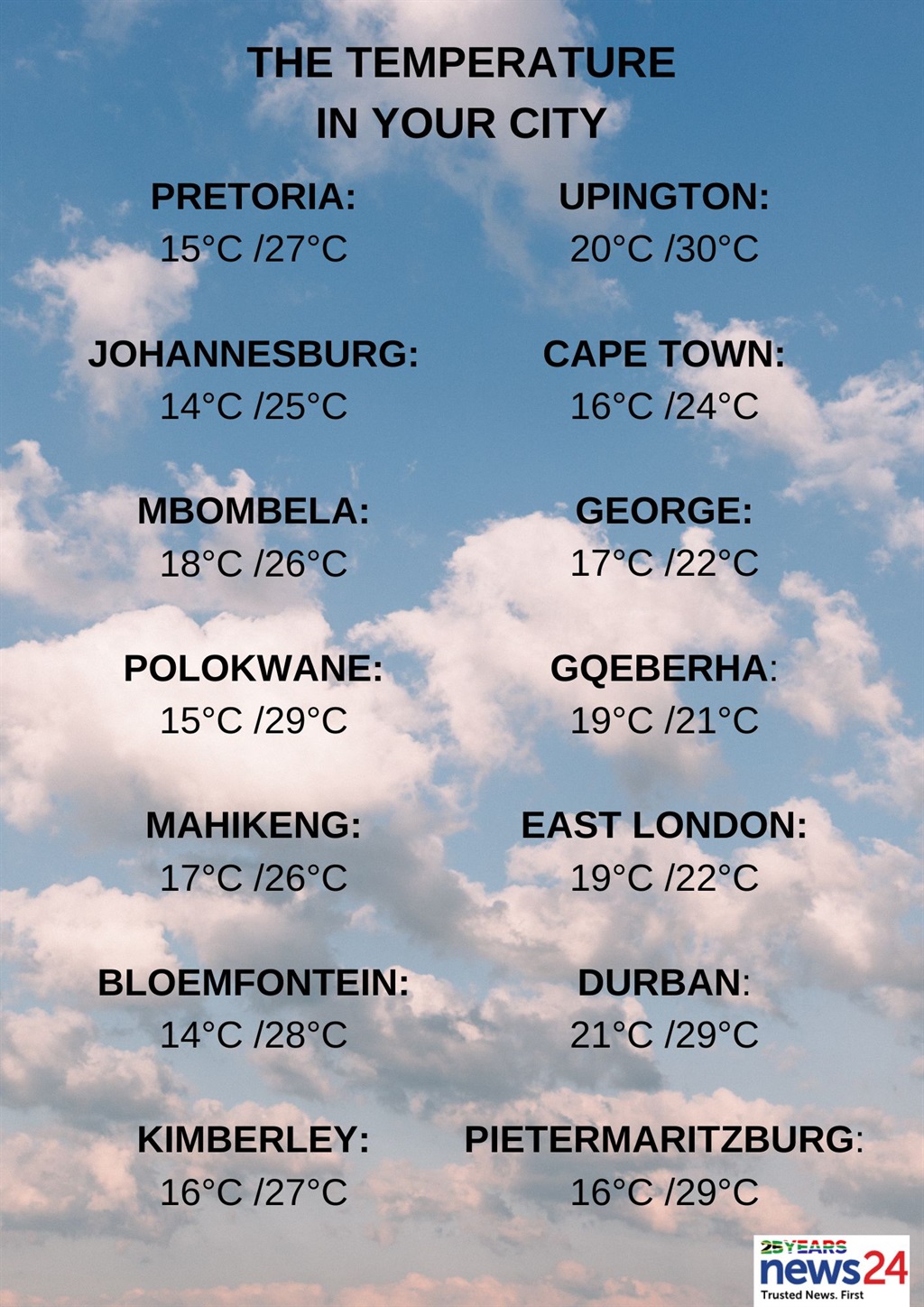
The weather in your region
Gauteng will be cloudy in the morning, otherwise partly cloudy and warm with isolated thunderstorms.
The expected UVB sunburn index is extreme.
Cloudy conditions with morning drizzle along the escarpment are forcast for Mpumalanga. Otherwise, partly cloudy and cool to warm temperatures are expected with isolated showers and thundershowers (except in the Lowveld) by the afternoon.
Limpopo can expect cloudy conditions with drizzle along the escarpment in the morning. Otherwise, it will be partly cloudy and warm to hot.
Partly cloudy and warm to hot conditions are forecast for the North West, with isolated showers and thundershowers, except in the north-east.
The Free State will be partly cloudy and warm, with isolated showers and thundershowers, but scattered in the west.
Morning fog patches are expected in the Northern Cape's extreme west, otherwise partly cloudy and cool to warm temperatures are forecast with isolated to scattered showers and thundershowers over the central and eastern parts.
The wind along the coast will be a moderate to fresh southerly to south-easterly reaching strong at times in places.
The Western Cape can expect cloudy conditions with isolated rain and showers along the south coast until the afternoon.
Otherwise, it will be partly cloudy and cool to warm with isolated to scattered showers and thundershowers in places over the eastern parts from the afternoon.
The wind along the coast will be light and variable in the eastern parts of the south coast at first. Otherwise, a moderate to fresh southerly to south-easterly is expected, becoming strong along the south and west coast at times.
The expected UVB sunburn index is very high.
Weather outlook for Wednesday (27 March) and Thursday (27 March):#saws#weatherupdate#weatheroutlook#southafricanweather#southafrican pic.twitter.com/YuQsEr6xeu
— SA Weather Service (@SAWeatherServic) March 25, 2024
Cloudy and cool conditions are forecast for the western half of the Eastern Cape with scattered showers and thundershowers.
The wind along the coast will be a light south-westerly, becoming easterly in the afternoon.
The eastern half of the province will be cloudy and cool with showers and thundershowers but widespread in the east.
The wind along the coast will be a light south-westerly, becoming south-easterly south of Coffee Bay towards the evening.
KwaZulu-Natal will have morning fog in places over the interior, otherwise it will be partly cloudy becoming cloudy and cool to warm with isolated to scattered showers and thundershowers, but widespread in the south.
The wind along the coast will be a light to moderate northerly to north-easterly but fresh in places, becoming a light south-westerly in the extreme south.
The expected UVB sunburn index is high.